Village History Timeline
- BC 12,000 - End of the Ice Age
- BC 1200-600 - Droitwitch Salt Containers
- AD 43 – 410 What Did The Romans Do For Us
- AD 685 - Founding of Saxon Church
- AD 1066 - Conquest and the Keynes Family
- AD 1773 - Andrew's and Dury's Map of Wiltshire
- AD 1783 – Terrier of Tythes and Glebe Lands for Somerford Keynes
- AD 1834 - Thefts and Deportations
- AD 1840 - Wedding of Queen Victoria
- AD 1870 - Imperial Gazetteer
- AD 1880s - Thatched Cottages In Somerford Keynes
- AD 1894 - Parish Council Founded
- AD 1920s - The First Village Hall
- AD 1925 - Serious Flooding
- AD 1930 - Rev Cooke
- AD 1966 - School Closes
- AD 1975 - By-pass Construction
- AD 1979 - New Village Hall Opens
After the Ice Age, which ended about 10,000 years ago, the melt water formed extensive river systems, washing sand and gravels into the region which formed the Upper Thames Valley. For the first 5000 years or so after the Ice Age humans were nomadic hunter-gatherers, giving way to simple farming communities in the Neolithic (4000-3000BC). There is evidence of husbandry of pigs, sheep and cattle, with cultivation of wheat and barley. Long barrows, stone axes, flints and pottery are useful indicators of the extent of human settlement.
A Palaeolithic hand-axe found in 1964 at Poole Keynes is now in Bristol City museum. A Neolithic axe from Somerford Keynes is in Malmesbury Museum and a similar flint axe has been recorded from Poole Keynes. Others have been found in South Cerney and are now in the Corinium Museum.
In the warmer (or perhaps less cold) periods of the Ice Age the humans hunted woolly rhinoceros, mammoths, bears and reindeer. A superb example of a locally found mammoth skull, from about 50,000 years ago, used to be displayed at the Gateway Centre near the junction of the Spine Road with the A419.
After the great thaw melt water formed extensive river systems, washing sand and gravels into the region which formed the Upper Thames Valley. The tundra-like landscape was replaced by woodland of various species, but particularly pine, birch and alder. These in turn gave way to deciduous woodlands. For the first 5000 years or so after the end of the Ice Age humans were nomadic hunter gatherers, giving way to simple farming communities in the Neolithic (4000-3000BC). A polished flint axe found at Somerford Lakes comes from this period. There is evidence of husbandry of pigs, sheep and cattle, with cultivation of wheat and barley. Long barrows, stone axes, flints and pottery are useful indicators of the extent of human settlement.
From two papers by Leslie Jones
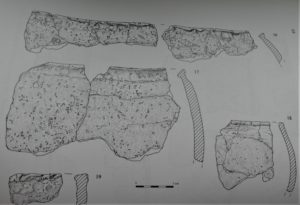
Between 1989 and 1996 a program of excavations in the area to the west of Spratsgate Lane, Somerford Keynes revealed prehistoric activity over a long period which included an iron age settlement. Finds included a small quantity of Drotwitch Salt Containers. The salt within them was traded from the brine springs of North Worcestershire.
The prime use of the salt would have been in food preservation, but possibly in other ways, including usage in animal diets, medicine and metallurgy.
Illustration from Glos County Council Archaeology Service report by Jo Vallender & others
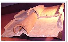
At Park Farm in Minety there were at least 10 tile-kilns and two stone buildings, making this the most extensive Roman brick and tile works found in Britain.
At Lower Mill Farm, on the site near Neigh Bridge of what is now Lake 77 – Spinney Lake (The first Lake on the left when going down the Minety Lane) a late Iron Age settlement was overlain by a late 1st Century large aisled building (27m x 9m), interpreted as a storage depot for the distinctive products of the Minety works used to supply the Roman City of Corinium and the many villas in the region.
A Roman road lead from Minety to where the Neigh Bridge now is.
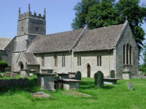
In AD 685 The Saxon King, Ethelred of Mercia confirmed the grant of 40 hides of land at Somerford on the River Thames to Aldhelm of Malmesbury, and we may assume that from that date a preaching centre was established at Somerford, and soon after at Ewen and Kemble, which also belonged to Malmesbury Abbey. The first converts were baptised in the Thames; mass was said first in the open air and then perhaps in a rough wooden shelter, and within twenty or thirty years a stone church was built at Somerford.
All that remains of the Saxon Church is a section of the north wall of the nave containing a very primitive tall, narrow doorway, which, experts say, might well have been built before the death of Aldhelm 709)
The above transcribed from “All Saints’ Church” by Canon Geoffrey Gibbon
Following the Battle of Hastings in 1066 William dispossessed the Saxon nobles and imposed the feudal system on England.
The church in England reorganised and William brought men from France to become bishops and abbots.
The status of women in the Anglo-Saxon period had been relatively high, with the opportunity for rights in land ownership. The Feudal system introduced by the Normans ended this.
In Somerford soon after conquest the land passed by marriage to Ralph de Kaaines
From ‘Through The Saxon Door’ by Geoffrey Gibbon
In the reign of Edward the Confessor, Somerford with many other manors was held by Alward, William the Conqueror granted it, with other fiefs scattered over six counties to Gilbert Maminot, Bishop of Lisieux, who was his personal physician and attended him on his deathbed. Gilbert’s lands passed to his nephew Hugh, whose daughter and heiress Alice married Ralph de Keynes (to use the modern-day spelling).
The de Kaaines or DeKaynes or even de Kahaynes famiies (ref The Place-Names for Gloucestershire by A H Smith) also held land at Milton where these days they pronounce it ‘Milton Keeeenes’ while we Somerford folk pronounce it correctly as ‘Kaaaanes’. The economist John Maynard Keynes descended from the same family.
We do not know the fate of Alward.
David Miles
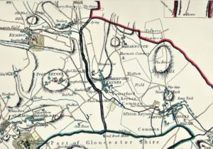
This was a large-scale map (2 inches = 1 mile) from an actual survey conducted by John Andrews and Andrew Dury issued in 1773 (pre Ordnance Survey), this being one part (of 36) of the whole of the county of Wiltshire*.
*Somerford Keynes was in Wiltshire until the 1890s.
The image is copied from a map supplied courtesy of Mr & Mrs de Bertodando
The map was dedicated to the ‘Noblemen, Gentleman, Clergy and Freeholders’ of the county in the hope of attracting subscriptions to cover the huge cost of such a venture, as far as is known the survey probably took between 5 and 6 years. The end result gave the wealthy patrons a large-scale map of their environs, hitherto unmapped in such detail. This was the age of the gallows, leech pools, smallpox and isolating houses, turnpike gates and windmills.
Andrew’s and Dury’s map of Wiltshire is the first map of the county after the works of Christopher Saxon (1579) and John Speed (1611) based on an original survey and not upon the work of those cartographers, (it was not until 1791 that the Ordnance Survey Office was set up by H.M. Government with the task of surveying the whole of Britain on a scale of 1 inch to 1 mile)
This map is coloured in detail, however the original maps were simply coloured to show the county boundary, where applicable and the hundreds (a sub-division of the county having it’s own court) – shown as a double line. When all the sections are put together, the dimensions for Wiltshire would be approximately 6 feet by 9 feet.
Careful study of this map will reveal that Minety, to the south of the Swill Brook, was then part of Gloucestershire. (That is except for the few acres immediately around Minety Church, which were in Gloucestershire!)
Tythes were paid as typically one tenth of all annual produce or earnings, formerly taken as a tax for the support of the Church and clergy.
Like any tax, tythes were not always popular!
All exemptions were keenly recorded, as was the case here in Somerford Keynes.
A glebe terrier is a Church of England written survey or inventory giving details of glebe, lands. These were lands directly owned by the Church of England to provide further income for the clergyman and his church.
D Miles
From a copy of the original in Glos. Record Office supplied by Judy Monger.
Reference P303 in 4/1 1783 Glebe Lands Terrier
John Dry Vicar
Vicar of Somerford Keynes 1750 – 1795
A true Terrier of all the Glebe Lands, Tythes, & all other Profits belonging this12th day of July in the Year of our Lord 1783 to the Vicaridge of Somerford Keynes as far as we know or have credibly heard by Conferences wth our honest Neighbours.
We present upon our Knowledg that there doth belong to the Vicaridge of Somerford Keynes, one Mansion House, one Stable, one Barn, & other Edifices.
We present upon our Knowledge that there doth belong unto the Vicaridge one Court, one Garden, two Closes, the one Pasture, the other Arable, containing together by Estimation Seven Acres, known by the Name of the Barrow Hill, bounded on the South by Wm Panter, on the East & West by the Highway, on the North by Common Barrow Hill & part of the F[ar]me Ground; the Hedges all round the Ground, except that against the Farm Ground, belong unto the Vicaridge. Likewise one Close laying in the North Field, by Estimation Seven Acres, bounded on the East & South by the Highway, on the North by the Grounds of John Ferrebee, On the West by a Ground belonging to the Farm call’d Shuters Hill, the [hedges around] the Ground belong to the Vicaridge: Also one Acre known by the Name of No one Acre, laying in an Inclosure belonging to John Ferrebee one Meadow by Estimation ten Acres bounded on the North by the Mead Land, on the East by Gorges Foyle Esqr, on the South by the River, & on the West by the Widow Cleffard, the Hedges on the West & North Quarters belong to the Vicaridge. One peice of Arable Land laying in the Farm Feild by Estimation Seven Acres, laying near the old Coppice shooting from R[ ]dge way down to the River. We present upon our Knowledge that all manner of Tythes arising & growing within our Parish are to be paid to the Vicar thereof, excepting the Lands & Grounds following (Viz) the Lands & Grounds belonging to the Farm now in the Posesion of Gorges Foyle Esqr & MrRich[d] & Edward Southby & their under Tenants: Also one Close call’d Stone Stich, Also three Meadows & one little Close in the Posesion of Gorges Foyle Esqr, wch Grounds are held by the Posesors of them Tythe free. All the Rest of the Parish is tytheable & payeth Tythes according to the Custom of the Place. There are certain Lands [&] parcells of Meadow [wch] lay in the Farm & other Grounds wch are tytheable, & pay Tythes to the Vicar; (Viz) one Ham in a Meadow known by the Name of Pilsmore, call’d by Name Constable’s Ham, by Estimation three Acres laying at the South East Corner of Pilsmore now in Posesion of Gorges Foyle Esqr Also one Ham laying in a Ground call’d lower Stedham, known by the Name of St John’s Ham, by Estimation two Acres, laying by the River near Poole Moores: Also one Acre more in lower Stedham laying on the East Side of the Ground. The Acre is known by the Name of Wells’s Acre, the Ham is call’d Constables H[a]m in Pilsmore; [&] St [Jo]hn’s Ham & Wells’s Acre in lower Stedham ar[e] in the Posesion of Mr Edward Southby or his under Tenants.We present that there are Twenty Beasts Pastures, & Sixty Sheep Pastures belonging to the Vicaridge in Commons & Common Fields according to the Custom of the Parish. Memorandm There was a Ter[ri]er laid in at the office of Salisbury in the Year 1605wch doth testifie that the Vicar of Somerford Keynes for the time being, did receive all manner of Tythes arising & growing upon the Farm, as well small Tythes as great without Denial until Mr Harper was instituted Vicar thereof. We present that the Farm doth Pay Ten Pounds a Year unto the Vicar as a Due belonging unto him.
WILTS ASSIZES SALISBURY, Wednesday July 16, 1834.
Before Mr. Justice Patteson.
John and William Ritchens were convicted of stealing, out of the dwelling house of Thomas Westmacott of Somerford Keynes, a quantity of bacon and other pig-meat, his property. Sentenced to 4 months hard labour.
TRANSPORTED
Wiltshire Independent, 14 December 1837
Henry Dobson for trial, charged with having entered the dwelling-house of Rachel Cook, and stolen therefrom several articles of wearing apparel, at Somerford Keynes.
At the Wiltshire Quarter Sessions in January 1838, Henry Dobson was transported for 10 years, for burglary in the dwelling-house of Rachel Cook.
Devizes & Wiltshire Gazette, 12 July 1849.
WARMINSTER SESSIONS
Robert Skuse, was sentenced to 7 years transportation
For stealing 6 sovereigns, the property of Edward Telling of Somerford Keynes.
At the same hearing 3 others were given the same sentence –
One stole a silk pocket handkerchief
One stole an umbrella
One stole a handkerchief.
Robert Skuse was one of 292 convicts (287 landed) transported on the Pestongee Bomangee.
He left Plymouth on 16 April 1852 and arrived, assuming he survived the voyage, in Hobart, Van Dieman’s Land (Tasmania) on 31 July 1852.
Transportation ended in 1853
At Somerford Keynes, the auspicious event of the Queen’s marriage will never be forgotten. The venerable and truly Christian Minister acted in a most munificent manner; he distributed amongst the poor of his parish three sheep, and his amiable daughter collected all the young people, and treated them with excellent cake and wine. The joy and delight of the recipients were fully depicted in their countenances, and the honour and respect paid to their worthy Pastor and his daughter were most exemplary.
Salisbury & Winchester Journal.
17 February 1840.
SOMERFORD-KEYNES, a parish, with a village, in the district of Cirencester and county of Wilts; 2 3/4 miles N by E of Minety r. station, and 4 1/4. S of Cirencester. Post town, Cirencester. Acres, 1,640.
Rated property, £1,855. Pop., 386. Houses, 80. The property is divided among a few. The living is a vicarage in the diocese of Gloucester and Bristol. Value, £261. Patron, not reported. The church is good.
Source: The Imperial Gazetteer of England & Wales [Wilson, John M]. A. Fullarton & Co. N. d. c.
[1870-72].
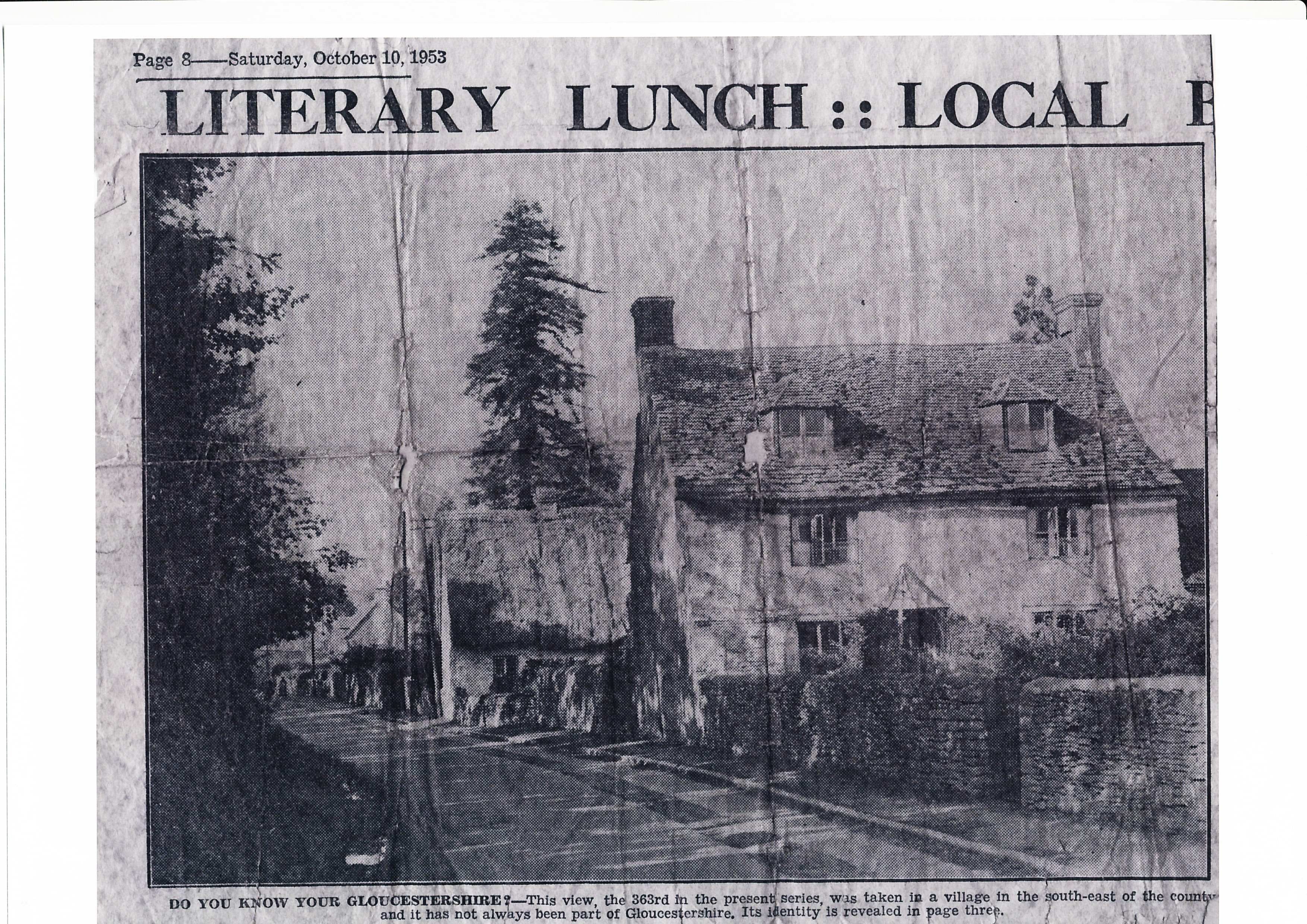
There are no longer any thatched cottages in our village, the last one caught fire and burnt down in the 1950’s. It stood between the present Croft Cottage and the Baker’s Arms. The newpaper cutting is from October 1953.
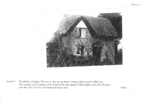
Another tiny ‘one up one down’ cottage appears in a photo taken in the 1930s. It’s ruins are at the rear of Blencathra in Mill Lane.
In the latter years of the 19th centuary the Ockwells lived at what was known as Village Farm.
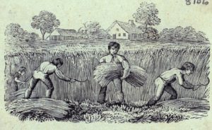
A photo dating to the 1880s records a group of workers before a cottage belonging to the Ockwell Family. It’s location is not certain. It is thought that this cottage was demolished in 1917 and replaced by the present house, now called Little Stedham which stands in The Street almost opposite to Water Lane. The doorway at the end was to a separate cottage where Miss Ockwell’s father lived.
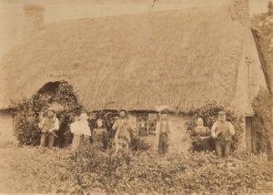
The Ockwell family have lived in the village for many years, possibly as far back as the 1500’s. Notice the tools held by the men.
There is an outside possibly that this photo was actually taken elsewhere: at an early Beech Cottage (which stands where Mill Lane meets The Street). Another Ockwell family lived there in the early years of the 20th century, however: the chimney’s locations do not support this theory.
Judy Monger
On the 4th December 1894, following the Local Government act of that year, a village meeting was held in the Schoolroom at Somerford Keynes with the Vicar, the Rev William Fawcett, in the chair. The Chairman explained the idea of these new Parish Councils and the meeting agreed to establish one to serve Somerford Keynes and Shorncote.
Accordingly the first Parish Assembly, or Annual Meeting, was held on the 25 March 1895 and the first Parish Council was elected.
The five members were: Thomas Bowle, farmer who rented Croft House; Henry Freeth, farmer, who rented the Manor; Thomas Westmacott, baker and grocer; Richard Bowley, labourer (who later kept the village shop); and John Williams Browning, the Vicar’s gardener, who lived in Queen’s Cottage.
The first important business was to consider the proposal to move the parish from Wiltshaire to Gloucestershire.
From the history ‘Somerford Keynes Parish Council’ authored by Roger Sleeman assisted by others from the village
A large number of village halls were built in the years immediately after the First World War with many dedicated to the fallen of the conflict. This was intended as a way of rebuilding communities after the loss of so many of the young men.
Somerford Keynes’ first hall was a former army hut erected on the same site as the present hall.
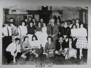
David Miles. The photo is of the youth club in 1959
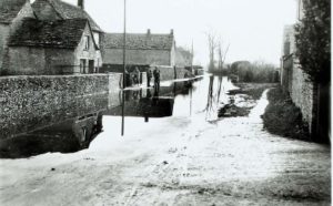
Over the years serious flooding has occurred in the lower part of the village, lapping up the road as far as the telephone box. The back and white photo shows the flooding of 1925, although the phone box was not there then!
Previous flooding also occurred in 1919, 1924 and 1926. Since that time the Thames has flooded the village in 1947, in the 1960s and most recently in 1992.
Thankfully, although the fields next to the Thames still suffer winter inundations, the village has not flooded since 1992, all thanks to improvements made by the Environment Agency.
1925 Photo courtesy of F Willavoys
David Miles
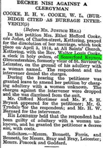
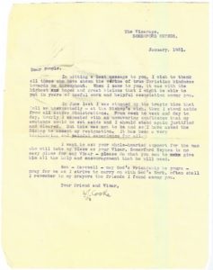
The Rev Cooke was taken to court for a divorce due to adultery in 1930 and subsequently he resigned in 1931
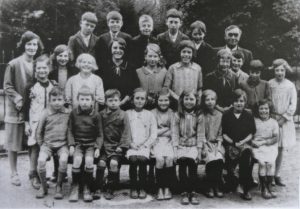
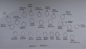
In 1966 our village school closed and the children were bused to South Cerney School.
Jenny Mulcock, nee Smith, who was a pupil in the 1960’s, talking to David Miles.
“There was just the one classroom and a small kitchen on the side nearest the field where the cook prepared meals, although many of us walked home for lunch.
Normally we had just one teacher for all of us, infants and juniors: a Miss Mann and possibly a Miss Richards? The small playground was at the front. While we did not have a school playing field for summer sports days the farmer allowed us to use the adjacent field.
The classroom was heated by a coke stove with rails around it to stop us incinerating ourselves.
When we fell over we went across the road to School Cottages to be patched up.
The windows were set up high, so we were not distracted by the goings on outside.”
The Photograph is from 1929/30.
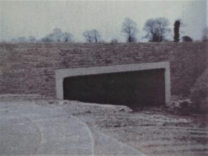
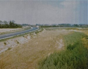
Prior to construction of the eastern section of the Spine Road gravel lorries from the quarries passed either east via the narrow entrance to Water Lane and before a weight restriction was imposed Roger Constant’s 8 wheelers traveled south down the narrow Minety Lane to Silver Street, Minety.
I remember rather unexpectedly coming across the new Spratsgate lane junction on 26th June 1976, otherwise remembered as our wedding day.
Photos show the newly constructed road, devoid of hedges and other vegetation.
David Miles
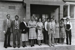
‘The new village hall in Water Lane was finally opened in October 1979. There had been several previous abortive attempts over many years to provide a permanent hall to replace the wooden huts used previously. All earlier proposals had failed and in December 1970 both the Village Hall Committee and the Parish Council agreed that the site should be sold as “there seemed little possibility of ever having a hall on the site”. Fortunately wiser counsels prevailed and, due to the commitment of the fund raising committee, led by Mike Chamberlain, a hall was at last built. It has proved a well-used asset to the village and was extended in 1992’.
From the history ‘Somerford Keynes Parish Council’ authored by Roger Sleeman assisted by others from the village
The eagle eyed will notice the wall stone is dated 1978.